Why a Park Loop Feels Easier to Join Than a Destination Walk
A park loop makes casual walking easier to join with visible landmarks, flexible stopping points, and a clear way to plan your return before setting out.
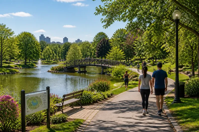
Is a park loop easier to plan than a walk to a distant destination? Often, yes: a park loop brings you back toward its starting area, so you can choose a modest circuit without arranging a separate trip home. Its landmarks and connecting paths also make it easier to understand where you are.
That return shape is useful for a casual walk or jog, but it does not make every loop simple. Some paths include steep slopes, uneven surfaces, or confusing branches. A little route planning helps you choose a circuit that suits the day.
A built-in return
A destination walk has a place to reach, such as a waterfront, viewpoint, or café. If you get tired before you arrive, you must decide whether to continue, retrace your route, or find another way back.
A loop builds the return into the route. Once you reach the far side, the path bends toward the area where you began. A park may also have connectors between its paths and entrances, giving you a shorter way back without repeating the whole circuit.
Check the park map or posted signs before setting out. A path that looks circular on a phone map may include a spur that leads away from the entrance. Look for signs showing which routes reconnect and which continue elsewhere.
Landmarks and connections
A footbridge, ball field, fountain, or trail marker can serve as a simple location reference. Instead of estimating how long you have walked, you can tell yourself, “I’m at the pond” or “I’ve passed the north playground.” These landmarks help you decide where to go next.
They are useful for meeting someone, too. “The bench beside the community garden” gives a clearer meeting point than “somewhere on the path.” Choose features that are easy to spot from the route and do not look much like nearby features.
Pay attention to connections between paths. A marked connector can lead back to an entrance, while a branch may take you deeper into the park. Knowing the difference helps you choose a route without needing to memorize every turn.
Choosing a route that fits
Before making a circuit your regular route, check the details that affect your comfort and access. Use the park map, signs, or a mapping app to answer practical questions:
- Starting point: Check whether the entrance is easy for you to reach and clearly marked. If it is, use it as your reference point; if not, choose another entrance shown on the map.
- Surface: Observe whether the route is paved, firm gravel, or uneven ground. If the surface suits your shoes or mobility needs, consider it; if not, look for a more suitable path.
- Landmarks: Check for visible features such as a bridge, field, or fountain. If you can identify them from the path, use them to orient yourself; if not, rely on labeled trail signs or choose a clearer circuit.
- Connections: Check which paths return to an entrance and which lead farther into the park. If a connector provides a clear return, keep it in mind; if the route is unclear, choose a better-signed circuit.
- Rest options: Look for benches, sheltered areas, and water fountains. If a useful stopping place is along the route, note its location; if not, choose a circuit with facilities that better fit your plans.
- Busy areas: Check for road crossings, playground traffic, and places where bikes and pedestrians share a narrow path. If those spots are manageable for your pace, continue; if not, choose a quieter section or another route.
- Short exits: Look for a connector or entrance that lets you leave the circuit early. If one is clearly marked, note it; if none is available, choose a shorter loop before you start.
A stroller, mobility device, or dog can affect which paths and facilities work for an outing. Park maps may identify paved routes, accessible entrances, restrooms, and leash rules. Follow posted access and path-use signs.
Walking or jogging?
The same circuit can suit a walk or an easy jog. Walkers might use a bridge or garden as a point to pause. Joggers can use a familiar landmark to check how they feel and choose whether to keep going at a comfortable pace.
On shared paths, leave room for people moving at different speeds. Follow local signs, pass with care, and avoid stopping in narrow sections. A conversational pace with a friend can make it easier to notice crossings and other path users.
Repetition can make a route easier to remember. Once you know where a circuit bends and where its connectors lead, less attention goes to basic navigation. You can still choose a partial circuit rather than completing the whole route.
A route in practice
Say you and a friend arrive at a neighborhood park after work. The map shows an entrance, a pond, a small footbridge, and a marked connector back to the gate. You agree to walk to the bridge, then check how you feel. If you want a shorter outing, you take the connector back to the gate; if you have time and feel comfortable, you continue around the pond. Either choice follows a route you have already identified, so neither requires an improvised way home.
Park loop questions?
Where should I start a park loop?
Choose an entrance shown on the park map or marked by a sign, then identify a nearby landmark. If you pause or meet someone, that recognizable point can help you orient yourself again.
Can I turn back before finishing the loop?
Yes, if the map shows a clear connector or return path. Check it before you set out so you do not mistake a branch leading farther into the park for a way back.
Is a park loop suitable for a first jog?
It may suit an easy first jog if the surface and incline feel comfortable for you. Choose a circuit with a clear return path so you can shorten the outing without arranging a ride from a distant endpoint.
How should I choose among connected loops?
Check the signs or map for the shortest, clearest circuit and note where it meets other paths. If a branch is poorly marked, choose the signed route rather than relying on an uncertain shortcut.
Plan one useful landmark
For a park loop, choose a visible landmark near the farthest point you plan to reach and identify a marked path back toward your entrance. This small amount of planning gives you a clearer sense of the route and helps you choose a circuit that fits the time, surface, and conditions you have that day.